Monthly Progress Update – November
Our application was filed with the Town of Prescott Valley on August 27th, 2021. The traffic study was filed with the Town in September. The Town of Prescott Valley staff is currently reviewing both of these documents and we will update this website as well as the surrounding communities when more information becomes available. Please do not hesitate to reach out with any additional questions in the meantime.
Changes as a Result of Community Input
PV 540 WILL NOT connect to Bradshaw Mountain Road until the first model home is built. Brown Homes has made a commitment that construction will access the site from SR-169. We originally proposed a 50’ fixed buffer and have since changed it to a Variating Buffer with a minimum 50’ depth and articulation to over 200’. Also, we have agreed to only build Single Family Residential homes within 100’ of the Quailwood Meadows perimeter.

The Name
This development WILL NOT use the name Quailwood Heights. We have heard concerns from Quailwood Meadows and have changed the name to PV 540.
Future Meetings
Please feel free to join us for an informational Open House to learn more about this project. This Open House will allow you to come and go at your convenience and ask questions about this proposed development.
September 16th, 2021 | 3:30pm – 6:00pm
BMMS Gymnasium
12255 Turquoise Circle Dewey, AZ 86327
The Proposal
PV 540 is requesting a density of 4.03 dwelling units per acre on approximately 541 acres for a maximum of 2,179 homes. The proposed density is based on Quailwood Meadows density of 4.03 dwelling units per acres (1,191 homes on approximately 295 acres). Neighborhoods within PV 540 will be similar to Quailwood Meadows and include a variety of housing options. A minimum fifty (50) foot wide perimeter buffer is proposed to ensure that homes within PV 540 will be setback from existing homes. A Perimeter Buffer is an open space corridor along the boundary of the Property adjacent to the Quailwood Meadows subdivision and the Outback subdivision as conceptually depicted in the exhibit below. Only single-family homes may be developed along the perimeter buffer. The density proposed in this PAD is very similar to Quailwood Meadows. A Master planned community with similar densities is the most compatible use adjacent Quailwood Meadows. Other uses could have far more impacts on adjacent properties.


Introduction
Fain Signature Group on behalf of the landowner (the “Owner”) owns approximately 542 acres of land, composed of three (3) contiguous parcels, located about one mile east of the intersection of Bradshaw Mountain Road and State Route 69 and one mile north of the intersection of State Route 169 and Outback Road (the “Property”). The Owner desires, with this Planned Area Development and Development Plan (together, the “PV 540 PAD”), to set a framework for future development of Property in a thoughtful and responsible manner.
The PV 540 PAD provides a framework for open space, circulation (both vehicular and pedestrian), and community amenities. It focuses on a limited range of residential uses, primarily low and medium density, with an opportunity for pockets of medium-high density as well as neighborhood services. The primary roadway circulation is designed to support the development of the Property while the framework provides both structure and flexibility that are key for a development plan to produce choice in types of environments, living units and amenities as well as in the design and development that to encourage neighborhood variety.
The Development Team

Current Property Owner
Community Outreach

Land Use Attorneys

Espiritu Loci Incorporated (ELI) is a planning and development assistance firm that specializes in the creation of spirited, one-of-a-kind settings for life.
General Plan
The Prescott Valley General Plan 2025, (the “General Plan”) was adopted by the Town of Prescott Valley (the “Town”) on August 9, 2012 and ratified on March 12, 2013. The General Plan establishes principles, goals, policies, and implementation strategies to help guide future growth within the Town.
The General Plan shows the area of the Property as PAD 5-II Land Use designation, a Tier II Growth Area. See Exhibit C – General Plan Land Use Designation. As intended with this designation, the PV 540 PAD permits a diverse variety of housing options and an opportunity for neighborhood services to serve the neighborhood and surrounding communities. The PV 540 PAD ensures orderly and thorough planning and review procedures that will result in urban design that will encourage variety in architectural design and site planning. It will permit flexibility in so that development may provide greater choice in the types of environments, living units, amenities, and an efficient, aesthetic and desirable use of open space in a manner that will produce an environment in harmony with the surrounding areas. The PV 540 PAD is consistent with the General Plan and the development of the Property is a logical extension of development.

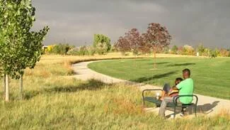
Open Space and Parks
The open space systems within the Property are essential community elements providing important gathering spots for both active and passive recreational uses for future residents. The open space system is characterized by three (3) types of open spaces that are anticipated as being private and for the residents of the community.
These are:
an open space corridor, often in the form of a landscape buffer, linear park, or greenway following a drainage corridor, roadway, utility corridor or neighboring properties,
neighborhood parks and open space areas, generally between one-quarter (1/4) to one and three-quarter (13⁄4) acre in size, dispersed throughout the community providing a local gathering node and/or landscape area, and
a recreation core, a centrally located community amenity, that may include a community center, trailhead and parking, and/or community-oriented services.
The open space system must include at least one (1) five (5) acre contiguous area of land. The area may be composed of any individual or combination of open space types and ownership.